SPECIAL WARNING
General Weather Evolution for the Next Days over the Ocean and Europe
Europe: Analysis & Forecast maps
Synoptic Update for Europe – 16 July 2026
After several days of summer warmth, Europe's atmosphere is about to undergo a marked change. A broad and complex low-pressure system, currently extending across France, the Bay of Biscay and north-eastern Spain (1015–1017 hPa), will deepen over the next 24 hours as it moves towards northern France and subsequently north-eastern Germany.
As it progresses northwards, the system will rapidly destabilise the warm air mass currently covering large parts of Western and Central Europe, creating favourable conditions for locally severe thunderstorms. The greatest risk of intense convective activity is expected across France, Germany and the Alpine region.
The Benelux countries should remain largely on the fringe of this deterioration. Only the far south-east is likely to experience more significant thunderstorm development, mainly across the provinces of Liège and Luxembourg and the Grand Duchy of Luxembourg.
During the weekend, the depression will reach the Baltic Sea, where its central pressure is expected to fall to around 997–998 hPa. In its wake, noticeably cooler air originating from the North Sea and Scotland will spread across our regions, bringing not only lower temperatures but also much more stable atmospheric conditions.
Little change is expected during the first part of next week. By Wednesday, however, a new weather disturbance accompanied by even cooler air and rainfall will move southwards from the North Sea towards our regions.
By next Thursday, an anticyclonic ridge is forecast to restore more settled conditions. Temperatures will remain pleasantly moderate and entirely in line with the seasonal averages expected for late July.
It is yet another reminder that the European summer is rarely monotonous, offering a subtle interplay between warmth, thunderstorms and welcome spells of refreshing air.
Probable weather evolution over Europe Likely trend (based on mid-tropospheric anomaly patterns)
https://www.bmcb.be/trend-europe-europa/
Update 16-6-26
Update – 16 July 2026: Synoptic Trend across Europe (24–30 July)
Europe's skies are once again preparing for a change of scene. After a few days under the influence of an anticyclonic ridge extending from the British Isles across our regions, bringing pleasant maritime air and seasonable temperatures, the atmospheric pattern is expected to evolve gradually.
Towards the final days of July, the airflow is likely to turn temporarily south-westerly, ushering in milder but also more humid and unstable conditions. Low-pressure systems tracking across our latitude – and at times even farther south – would bring a return to unsettled weather, accompanied by spells of rain that may occasionally become more significant.
Western Europe would thus return to a more dynamic weather regime, reminding us that summer is not only about warmth, but also about the perpetual dance between high and low pressure systems.
****************
National Thermal Indicator
MULTIMODEL BMCB
(These forecasts are generally updated daily)
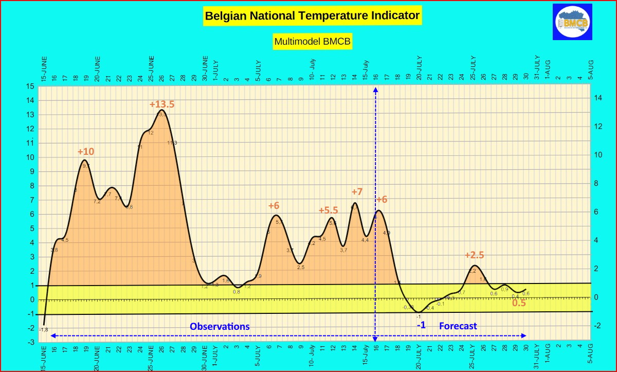
Update – 16 July 2026
Following the recent spell of summer warmth, Belgium is set to return to more temperate conditions. The Belgian National Temperature Indicator will peak at +6 over the next 24 hours, corresponding to daytime highs of 24 to 32°C across the country, depending on location.
A marked decline is expected from tomorrow onwards, with the indicator falling to -1 around 19 and 20 July. Daytime temperatures will then range between 17 and 24°C.
Thereafter, the remainder of the month looks more balanced. From 23 July until the end of the month, the indicator is expected to fluctuate between 0 and +3, broadly corresponding to daytime highs of 19 to 25°C. A modest return of warmer conditions remains possible around the weekend of 25 and 26 July, when temperatures could locally reach 22 to 29°C.
In other words, the Belgian summer should once again settle close to seasonal norms, punctuated by a few particularly pleasant and milder intervals.
*****************
Forecast for the coming days
Multimodel BMCB ( OPERATIONAL + ENSEMBLES ICON-GFS-ECMWF-AIFS-GCGFS )
Forecast of the range of temperatures, precipitations + general type of weather in Belgium
(These forecasts are usually updated daily)
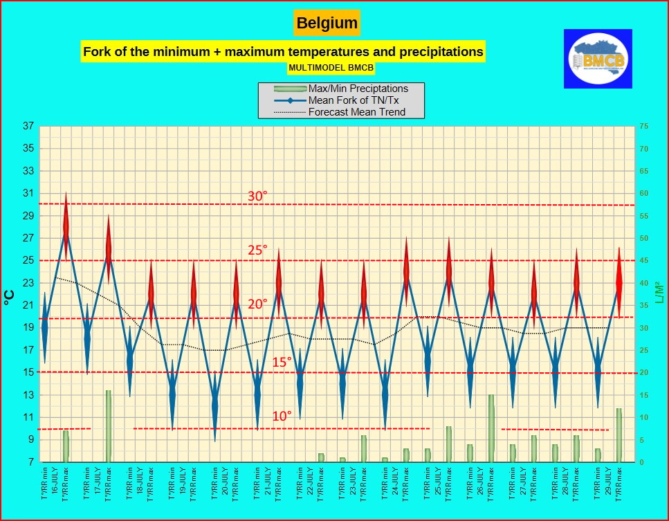
Weather evolution – 15 July 2026, according to the BMCB Multimodel
(operational models and ensembles ICON – AIFS – GFS – ECMWF)
A More Temperate Pattern Returns After a Brief Taste of Summer
After a few days of summer warmth, the weather pattern is expected to become more temperate and seasonable across Belgium. While Thursday and Friday will still bring rather warm conditions, particularly in the south of the country, temperatures will gradually ease back to values more typical for the latter half of July.
Thursday will be widely sunny during the morning, although isolated heat-induced thunderstorms may develop later in the day, mainly over the Ardennes and the Gaume region. These will remain highly localised. A brisk northerly to north-westerly wind will provide some welcome relief from the warmth.
On Friday, sunshine will alternate with cloudier intervals. A few showers and isolated thunderstorms are likely to develop later in the day, chiefly south of the Sambre and Meuse valleys. Temperatures will remain pleasantly warm.
The weekend will usher in cooler air from the north. Saturday will become increasingly sunny after a more variable start, while coastal areas are expected to enjoy abundant sunshine throughout much of the day. By Sunday, temperatures will have returned to values close to the seasonal average beneath a mix of cloud and sunny spells.
The week beginning 20 July looks generally favourable, with Monday and Tuesday remaining mostly dry and fairly sunny. Temperatures will be comfortable and close to climatological norms.
Beyond midweek, forecast guidance points towards somewhat more changeable conditions. After a largely dry Wednesday, occasional showers or spells of rain are expected to return from Thursday onwards. Rainfall amounts should remain moderate and unevenly distributed, while temperatures stay pleasantly mild before easing slightly towards the end of the period.
Overall, after a brief spell of summer warmth, Belgium's weather appears set to return to a more balanced late-July pattern, combining fine intervals with occasional weak disturbances and seasonable temperatures.
*************

SOURCE: METEOCONSULT
BENELUX:
Weather Outlook for 3-4 weeks
Weather trend for the next 3–4 weeks – Update 10 July 2026
Period from 25 July to 2 August
The latest model calculations once again confirm the scenario that has already been emerging: a strong area of high pressure is expected to remain established from the Maghreb through France and into the Benelux countries. This pattern would favour predominantly sunny, warm to very hot and exceptionally dry weather across these regions.
As a result, the current dry spell could persist into the beginning of August. At present, there are no clear indications of a fundamental change in the large-scale weather pattern, suggesting that the persistent high-pressure regime is likely to continue.
Week from 3 to 9 August
The models also offer little sign of a major change during the first week of August. A renewed influx of very warm air towards Western Europe remains the favoured scenario, which could lead to a significantly warmer-than-average and notably dry start to the month.
If this scenario is confirmed, drought conditions in many regions could become even more pronounced, extending what is already shaping up to be an exceptionally dry summer.
This 3–4 week trend is updated weekly. It should be regarded as a general guidance forecast, as the outlook may still evolve significantly with future model runs.
***************
Weather Outlook for 3 months
Summer 2026: Persistent Heat Expected Across the Benelux
Update – 11-7-26
The atmosphere appears to have settled into a remarkably persistent pattern. Since late spring, the same large-scale weather features have repeatedly shaped conditions across Western Europe: strong areas of high pressure anchored over the continent, while cut-off low-pressure systems west of the Iberian Peninsula act as an efficient heat pump. This configuration repeatedly draws very warm air northwards, producing prolonged dry spells and recurring heatwaves. August may briefly interrupt this pattern with a few thundery outbreaks, but without fundamentally changing the prevailing weather regime.
Globally, the return of El Niño deserves close attention. Although its direct influence on the weather over the Benelux remains relatively limited during summer, it reinforces an already exceptionally warm global climate background. Across our region, however, the dominant drivers continue to be persistent high pressure, increasingly dry soils and repeated intrusions of subtropical air.
August is expected to remain very warm, with temperatures averaging around 1.5°C above normal. The risk of additional heatwaves remains significant, although more frequent thunderstorms could provide temporary relief. Rainfall is likely to be highly uneven, however, and thunderstorms alone are unlikely to alleviate the ongoing drought, as intense downpours tend to run off rapidly rather than replenish deep soil moisture.
September may still feel like an extension of summer. While forecast confidence naturally decreases at longer lead times, high pressure is expected to retain a strong influence across Europe, keeping temperatures close to 2°C above the seasonal average. Atlantic disturbances may occasionally cross the region, but they are unlikely to trigger a lasting change in the overall weather pattern. Rainfall is expected to be close to seasonal norms.
October is currently projected to be relatively dry under the continued influence of high pressure across Western and Northern Europe. Temperatures should ease compared with the previous two months but are still expected to remain 0.5 to 1°C above average. Days may remain pleasantly mild, while clear nights allow for noticeably cooler conditions. Rainfall could once again end up below normal across much of the country, extending the ongoing dry spell into autumn.
**************
from ICON (replace location left above )
from ECMWF (replace location left above)